What happened
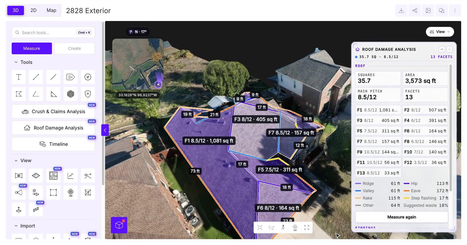
SkyeBrowse launched Roof Damage Analysis, which builds a 3D model from drone video, measures roof area, pitch, ridges and valleys, and scans up to 16 video frames plus eight photos in about 20 seconds.
Why it matters
The tool is pitched as a screening step so inspectors know where to look before climbing, with markings labeled 'Likely' or 'Possible' that a person must approve—it does not determine damage causes, insurance coverage or repair requirements.
WHO IT HITSRoof inspectors, insurance adjusters and public safety drone teams gain a way to prioritize which roofs need a physical visit after storms. Construction and survey crews also get GIS and CAD export options, including DXF contour files and ground-control-point corrections.
Summaries like this, every morning.
SkyeBrowse's platform converts drone video into 3D models and 2D maps, and its customers include public safety agencies, construction teams and commercial drone operators. The Roof Damage Analysis release extends that base into inspection work: after a pilot uploads video, the software identifies the roof, calculates area, pitch and individual facets, and measures ridges, valleys and eaves used in repair estimates. CEO Bobby Ouyang framed the product around storm response, where a crew may have twenty roofs to check and one ladder.
The damage scan marks findings as 'Likely' or 'Possible' and requires inspector approval, and SkyeBrowse explicitly limits the AI to screening rather than determining causes, coverage or repair requirements. The platform also incorporates NOAA storm reports covering nearby hail, wind and tornado events from the previous year, and users can generate a PDF report with measurements, diagrams, photographs, storm history and reviewer approval.
The update also widens the mapping side of the platform. Exports now cover common GIS and CAD applications, DXF contour files let survey and construction teams work with elevation data in CAD software, and users can correct 3D models using surveyed ground control points, with corrections carrying through to measurements, annotations and exported files. The release follows earlier additions—Timelines in October and AI-assisted vehicle damage analysis and crowd counting in September—that together reflect an expansion beyond 3D model creation into automated analysis, measurements and reporting.
Pick your industry and the AI tools you use, and get news related to your work every day.
Free · 30 seconds with Google · unsubscribe anytimeWhat is AIToday? →
Ask AI anything about this article. The AI reads this article, earlier AIToday articles, and Wikipedia, and cites its sources. Q&As are published on this page for other readers too.
Analog Devices completed its acquisition of Alif Semiconductor, announced November 3, 2026, pairing ADI's anal…

S&P Global published a roundup covering three topics: bioenergy with carbon capture and storage, October globa…

Tokyo Electron is shifting its equipment production from manual labor to automation, deploying AI and robots…

At CEATEC 2026, Mitsubishi Electric demonstrated a screw-tightening AI trained on about 2,000 images per screw…

Daiwa lowered its target price for Fanuc, while noting that the coming AI era should act as a tailwind for bot…

Tokio Marine & Nichido Fire Insurance announced on Oct 26, 2026 that its AI Robot Insurance, offered from Nove…