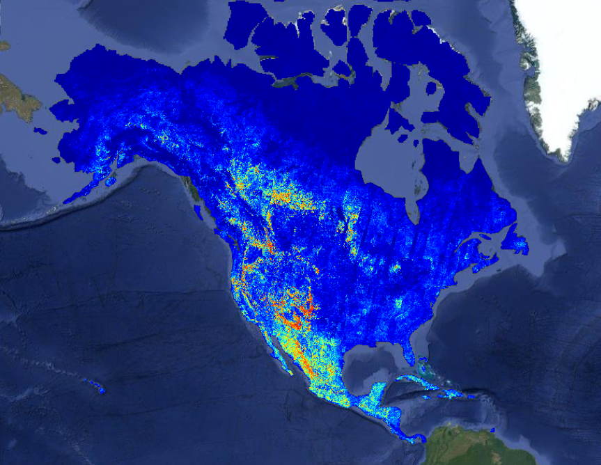
Allen AI released the OlmoEarth Platform, infrastructure that lets organizations run satellite-based AI models across continent-scale areas in about a day—processing terabytes of imagery for a fraction of a penny per square kilometer. The platform solves a critical gap: environmental groups working on deforestation, food security, and wildfire monitoring now have managed access to large-scale geospatial inference without needing their own ML engineering teams.
Summaries like this, in your inbox every morning.
Sign up free →What happened
Allen AI released the OlmoEarth Platform, infrastructure for running large-scale geospatial inference using its OlmoEarth foundation models (pretrained on roughly 10 terabytes of multimodal satellite data). The platform can process continent-scale areas in roughly a day, handling dozens of terabytes of imagery at a cost of fractions of a penny per square kilometer.
Why it matters
Environmental organizations—governments, NGOs, conservation groups—lack the engineering teams to manage the full lifecycle of ML models for applications like deforestation monitoring, food security, and wildfire risk. The platform bundles fine-tuning, evaluation, and large-scale inference into a single managed service, removing infrastructure as a barrier to adoption.
What to watch
Allen AI's roadmap includes automated scheduled runs triggered by new imagery, change-detection alerts, agentic tools for non-specialists, faster model architectures, additional satellite sensors and weather data, precomputed embeddings at global scale, and multi-cloud deployment. The platform currently operates on Google Cloud.
Allen AI released the OlmoEarth Platform, a managed infrastructure service for running large-scale geospatial inference using its family of OlmoEarth foundation models. The models were pretrained on roughly 10 terabytes of multimodal satellite data and are already being adapted by governments, NGOs, and mission-driven organizations for applications including deforestation monitoring, food security, and wildfire risk.
The platform addresses a fundamental gap. Allen AI has operated geospatial software platforms like Skylight and EarthRanger for over a decade and found that most environmental organizations—the ones best positioned to use geospatial AI—lack the engineering teams to manage the full lifecycle: labeling data, fine-tuning models, and running large-scale inference. The OlmoEarth Platform wraps that entire workflow into a managed service, eliminating infrastructure as a barrier to adoption.
Earth observation inference presents distinct challenges compared to typical ML workloads. A single job can process terabytes of data and run for hours; inputs span multiple spectral bands, sensor types, and time steps across large geographic areas; satellite data comes from multiple providers using different projections and resolutions; and every output must remain precisely aligned with the same coordinate grid as adjacent areas. Prediction jobs often spend more time downloading and preparing imagery than running the model itself. The platform addresses this by dividing each job into three hardware-matched stages: CPU-intensive data acquisition and preprocessing (fetching, reprojecting, aligning, and normalizing imagery), GPU inference (running the model's forward pass), and CPU-intensive postprocessing (stitching outputs into user-friendly formats like Zarr, GeoTIFF, or GeoJSON).
Parallelism is engineered into the core. The platform divides each geographic region into partitions sized for individual compute instances (workers), then subdivides those into smaller windows that can be processed independently. A state-sized area might become roughly a hundred partitions; a continent-scale run can become thousands. Adjacent partitions overlap slightly, and the platform reconciles that overlap when outputs are assembled. Because partitions are independent, work can run across thousands of compute instances simultaneously. When generating a wildfire-risk map covering all of North America, the run used roughly 19,600 CPUs and 994 GPUs in parallel, with network throughput exceeding 168 GB/s. This parallelism reduced an estimated 4,737 hours of serial compute to about 30.5 hours of wall-clock time—a 155× speedup. The platform can process continent-scale areas in roughly a day, handling dozens of terabytes of imagery at a cost of fractions of a penny per square kilometer.
Managing satellite data sources requires careful orchestration. Given a geographic region and time range, the platform determines which satellite scenes should feed the model by querying across providers with different catalogs, formats, and publication delays. For optical imagery like Sentinel-2, the platform prioritizes the least-cloudy scenes; for synthetic aperture radar, polarization channels may matter more. Rather than overwhelming external STAC (Spatio-Temporal Asset Catalog) APIs with thousands of concurrent metadata queries, the OlmoEarth Platform maintains its own metadata index, updated as new imagery is published. For datasets hosted through AWS Open Data, it receives SNS notifications for each new scene; when a provider lacks a change stream, it polls every few minutes. Each index entry stores scene metadata along with pointers to every cloud-optimized location where pixels are available, allowing the platform to perform windowed reads that retrieve only the bytes needed for a given partition.
The platform is designed to recover automatically from the failures inevitable at this scale. Every task is reentrant and idempotent, so intermittent failures can be safely handled by rerunning. The system tracks tasks, retries automatically, falls back to alternate providers when available, and distinguishes between retryable and fatal errors. A separate monitoring process detects runners that have stalled and restarts their tasks.
Allen AI's roadmap reflects gaps identified by partners. Among planned capabilities are automated model runs (scheduled in advance or triggered when new imagery arrives), change detection and alerts (notifying users of deforestation or flooding as events rather than static maps), agentic tools that lower the barrier for non-specialists, faster model architectures, additional satellite sensors and weather data integration (ERA-5), precomputed embeddings at global scale to replace full forward passes for many tasks, and multi-cloud deployment (currently on Google Cloud, designed to support AWS and on-premises environments). The company frames this as the beginning: geospatial foundation models and their operationalization remain an emerging technology, and many organizations best positioned to use them—those in conservation, food security, disaster response, and climate—have never had access to infrastructure at this scale.
Allen AI has spent over a decade operating geospatial software platforms like Skylight and EarthRanger, gaining firsthand knowledge of what environmental organizations actually need: not just open models, but the full operational infrastructure to run them reliably at scale. The OlmoEarth Platform reflects that experience. Rather than releasing another open-source model that research teams and well-staffed companies can fine-tune and deploy on their own, Allen AI has built a managed service layer that handles the engineering complexity most environmental nonprofits and government agencies cannot tackle internally.
The technical approach reveals how differently Earth observation inference behaves from typical ML workloads. A single job can move terabytes of data and run for hours—far longer than an LLM processing a paragraph. The platform addresses this by dividing work into three specialized stages: CPU-heavy data acquisition and preprocessing (fetching imagery from multiple providers, handling clouds, aligning projections), GPU inference (the forward pass itself), and CPU-heavy postprocessing (stitching overlapping windows into seamless maps). This hardware-aware architecture keeps expensive GPUs fully utilized while assigning I/O-bound work to cheaper CPUs.
Parallelism is the system's other pillar. A continent-scale run can spawn thousands of independent partitions; because each window can be processed independently, the platform achieved a 155× speedup on North America's wildfire map by running 19,600 CPUs and 994 GPUs in parallel. The roadmap signals Allen AI's intent to automate the user experience further: scheduled runs, change-detection alerts, and agentic tools that will let non-specialists define tasks without deep ML expertise. This positions the platform not just as infrastructure, but as a pathway for conservation, food security, and disaster-response teams to act on satellite data as it arrives.
AI-summarized, only the topics you pick — one digest a day via Email, Slack, or Discord.
Free · takes 30 seconds · unsubscribe anytime
No comments yet. Be the first to share your thoughts!
Log in to join the discussion


Get curated AI news from 200+ sources delivered daily to your inbox. Free to use.
Get Started FreeFree · takes 30 seconds · unsubscribe anytime